Zone in on Slides with GPS Tracker
After several unseasonably heavy rainstorms, a 260 acre landslide occurred at Trapper Coal Mine in northwest Colorado. Fortunately, the area was evacuated prior to the slide and no one was injured. In areas, the slide displaced ground more than 400 feet. Trapper Coal Mine is the second largest coal mine in Colorado and has been operational since the late 1970s. The mine produced more than two million tons of coal in 2008. Several mineable coal seams are located beneath the slide zone. If the slide were to reactivate, by natural catalysts and/or mining activity, loss of life and equipment would be devastating. Trapper Mine determined surface and subsurface slide zone monitoring as a main segment of the safety solution.
Applied Geomechanics designed an instrumentation array consisting of 1) GPS (Global Positioning System)—to monitor surface displacement in three dimensions; 2) In-Place Inclinometers—to measure subsurface rotation in zones prone to sliding; and 3) Vibrating Wire Piezometers—to measure subsurface pore pressure. All data is radioed to the main Trapper office and then fed, via the Internet, to a secure data server where it is processed and archived. The sensors monitor surface and subsurface changes and help the Trapper Mine staff identify slide precursors and evacuate the area appropriately.
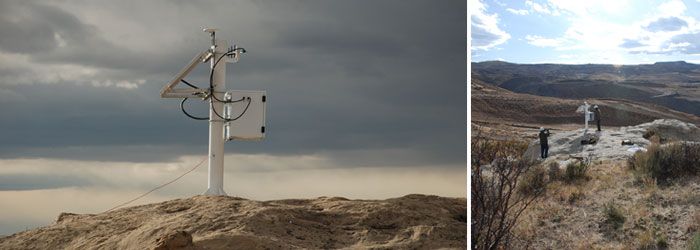
Three GPS monitoring stations were constructed in the slide zone. A fourth station located outside the slide area acts as a reference and repeater station. Four boreholes were drilled about 200 feet; each hole was cased with RocTest Inclinometers casing. Each borehole contains two fully grouted piezometers and three in place inclinometers (Little Dippers). Each instrumentation station is equipped with audible sirens and strobe light alarm systems, radio equipment, solar panel, and batteries.
Each station consists of
- Sturdy pillar mounted to a square concrete block
- Solar panel, voltage regulator, and battery.
- A central powered switch.
- Automated data collection system consisting of a data logger, multiplexer, and vibrating wire interface
- Warning sirens and strobe lights
- Intuicom radio system with directional YAGI antenna
- GPS receiver and external antenna
- Lightning suppression systems
- Each borehole has the (2) Peizometers and (3) Inclinometers
GPS
Global Positioning Systems (GPS) measure three dimensions of movement and can operate remotely anywhere in the world. Because GPS is a satellite-based system, it is often ideal for monitoring large structures such as mines, landslides, dams, volcanoes, land subsidence, large building, bridges, and oil platforms. Applied Geomechanics’ innovative receiver design paired with 3D Tracker software can provide 3D, real-time data with 1mm accuracy. Applied Geomechanics designs each GPS monitoring system to fit a project’s specific needs. Their experienced field engineers have installed GPS systems all around the world in various conditions.
Global Position Systems (GPS) consist of a ground receiver and a satellite network originally intended for United States military use. In the 1980s, the government made the positioning technology available for civilian use. GPS can precisely locate positions anywhere in the world, in any weather condition, and any time of the day. Coupled with Applied Geomechanic’s 3D TrackerTM software, GPS can provide continuous 1 mm accuracy monitoring.
There are approximately 30 GPS satellites circulating the earth; each satellite’s orbit path is precisely defined. The distance between a satellite and a ground receiver is calculated by correlating signal travel time with known satellite orbit. With four satellites; the ground receiver can triangulate a 3-dimensional position.
However, atmospheric noise can introduce large errors in receiver locations. Applied Geomechanic’s 3D TrackerTM software can offer 1 mm accuracy by use of triple differencing processing, a proprietary filtering technique. 3D Tracker saves information for post processing but also offers a graphical user interface providing real-time information. 3D Tracker graphical screens are user-configurable and clearly display information such as the current 3D displacement vector, the current rate of change, and the displacement history for each site.
Because GPS receivers use radio to communicate with 3D Tracker, arrays can monitor large areas such as Trapper Mine’s 260 acre slide zone. Via satellite communication, GPS triangulates a 3D position. Large land areas are a challenge for more traditional monitoring techniques, especially if 3D displacement vectors are required. Because the extensive GPS satellite network, receiver triangulation is possible even in remote locations.
A GPS station, or monument, consists of a steel post attached to a 4ft x 4ft x 4ft concrete pad. Each GPS pad must be placed on competent ground so monument settling will not induce positioning noise. Instrumentation enclosures bolted to the post contain the GPS receivers, radio communication equipment, batteries, and automatic data acquisition system for the piezometers and inclinometers. A solar panel, GPS and YAGI antennas are also attached to the monument post.
Inclinometers and Piezometers
Little Dipper In-Place Inclinometers are economical biaxial instruments for monitoring rotation of inclinometer casing. The Little Dippers are connected by low-cost fiberglass connecting rod, forming a string of inclinometers in the cased borehole.
At Trapper Mine the Little Dippers were installed with universal pivots separating hinged segments. Each segment measures the lateral displacement of a discrete ten foot interval in the borehole. Monitoring intervals were placed based on suspected slide planes.
Vibrating wire piezometers measure groundwater pressure which is needed for evaluating pore pressure variations near slip surfaces. Each instrument has a magnetic wire anchored at one end and attached to a moveable diaphragm at the other. As the pressure change, the diaphragm expands or contracts. By analyzing the frequency of the attached wire, one can determine pressure.
Two piezometers are installed in each borehole and are attached to the outside of the casing. The piezometers share a borehole with the three Little Dippers, installed inside the casing. The piezometers are attached to the outside of the casing; once the casing is installed grout is poured between the outside of the casing and the borehole wall. This fully-grouted method was used so the piezometers and Little Dippers could share a borehole and the piezometers could be installed and multiple levels.
Each borehole is continuously monitored with an automatic data acquisition system consisting of a data logger, multiplexer, and vibrating wire interface. The acquisition system shares power and telemetry with the GPS system via Intuicom radios.
Telemetry and Atlas
Intuicom multipoint radios transit data from each site through two repeater stations to the Trapper Mine office. Hilly topography prevented the remote stations transmitting data directly to office. The inclinometer and piezometer data is saved to a server in the Trapper Mine office. The GPS data is processed by 3D Tracker on the same Trapper Mine office server. The processed data GPS files and inclinometer/piezometer files are transferred to a secure Applied Geomechanics Data Center server. All data is archived both on the Trapper Mine server and the data center server.
Atlas is Applied Geomechanics’s monitoring software that runs on the Applied Geomechanics Data Center server. Atlas Monitoring Software is specially designed to process and distribute data collected from geotechnical sensors and users can access Atlas through the standard web browser. With the exception of GPS data, which is more thoroughly processed by 3D Tracker, all imported data is processed by Atlas as it is imported. This allows Atlas to scan for alarm conditions
Atlas scans all incoming readings for user specified alarm conditions. Users can set several tiers of alarms with notification to different groups. If a sensor goes into am alarm condition, a Trapper specified group is notified by e-mail and text message. Some alarm conditions send a message to the monitoring stations and trigger the audible sirens and strobe lights notifying miners to evacuate the area immediately.
The main benefit of using Atlas is it organizes data and presents it in meaningful ways. Aerial plan views allow the user to quickly view sensors. Varieties of plots can be created correlating information in different ways. Atlas can even generate pdf reports and send them to e-mail groups. All plots and reports are user configured, no high-level administration is required. Atlas is the tool that allows the different monitoring technologies applied at Trapper Mine to be brought together.
Applied Geomechanics designed an instrumentation system for a large, active landslide in Trapper Coal Mine. Three GPS sites measures three dimensional surface movement. GPS processing software help achieve 1mm accuracy. Four subsurface arrays measure tilt and pore pressure with inclinometers and piezometers. The subsurface stations share power and communication systems. Atlas, Applied Geomechanics’s web-based data monitoring software brings these three monitoring technologies together. Trapper engineers can configure plots to visualize their data and set alarms to help keep mining personnel safe.